
More About Teesdale and Lunedale Parish
Teesdale
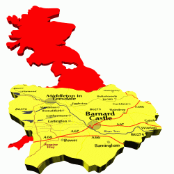 Teesdale has an area
of some 84.000 ha with a total population of 24,000 within County Durham and
is a largely peaceful corner of England. Over 50% is within the North Pennine
Area of Outstanding Natural Beauty. Many of the villages are conservation areas.
Teesdale has an area
of some 84.000 ha with a total population of 24,000 within County Durham and
is a largely peaceful corner of England. Over 50% is within the North Pennine
Area of Outstanding Natural Beauty. Many of the villages are conservation areas.
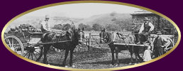
Most of the outstanding features of Teesdale are natural; superb open countryside of pasture and moorland- High Force and Low Force waterfalls are major tourist attractions. Teesdale also has outstanding man made features, Raby Castle, home of the Lords' Barnard since 1626. and The Bowes Museum. A rich history of mining, farming, the feudal system and culture are interwoven to create a diverse district inhabited by an equally diverse population with many new comers bringing their own culture and life styles. A truly warm welcome awaits you anywhere in Teesdale.
Barnard Castle is the main market town and is rich in history with its cobbled market place and narrow winding passages between streets. Named after the Norman Castle around which the town was built 'Barney', as it's known to the locals, has excellent shops and a Wednesday market.
Middleton in Teesdale, the only other market town, has distinctive Victorian architecture that reflects the previous prosperity of the area through Lead Mining.
The parishes within the Mid Teesdale Area use both Middleton in Teesdale and Barnard Castle as their town and for the usual services. There are doctors' surgeries at both and a hospital in Barnard Castle without A&E facilities. It should however be noted that some of the residents in Lunedale are closer to the Cumbrian border and naturally lean towards the towns of Brough and Kirkby Stephen.
The parishes within Mid Teesdale, Holwick, Mickleton, Lunedale, Romaidkirk, Hunderthwaite and Cotherstone were until 1974 part of North Yorkshire before becoming County Durham. There are still a number of people in the mid-dale who think of themselves as Yorkshiremen.
The district has an air of the past about it and having the lowest population per square mile of any other district in England. Teesdale offers space and scope to live In peace and tranquillity whilst stiti being within about an hours drive of York, Newcastle, Durham, The Scottish Borders and the Lake District.
Lunedale Parish Profile
There are forty houses spread throughout the dale, some clustered in a couple of tiny hamlets, Bow Bank and Thringarth and others at Laithkirk, Carlbeck and Wemmergill, the remainder are scattered by the roadside or along farm lanes. The only exception to this distribution is Cronkley Farm, which lies on the south side of the River Tees in Upper Teesdale and is accessed via the B6277 Middleton-In-Teesdale to Alston road.
Many of the oldest farmsteads follow the 'longhouse' pattern where the dwelling is protected from bad weather by a barn to the west or sometimes a barn at both ends. The 'grain' of the valley runs approximately east west and many of the properties face south or south by southeast. Aspect is very important in Lunedale,south facing fields are more productive and trees have been planted to provide shelter from the prevailing southwesterly wind.
The B6276 runs the length of the parish from Lunesbridge Viaduct in the east to the Cumbrian,(formerly Westmorland), border in the west. This is a trans-Pennine route and the highest point on the pass, just over the border on the Cumbrian side, is at 482m. Prior to boundary changes in 1974, Lunedale was the most northwesteriy part of the North Riding of Yorkshire and the River Tees formed the county boundary, The parish is now in County Durham and covers an area of 90 sq km.
Lunedale forms part of several nationally and internationally important habitats and conservation areas because of its diversity of minerals, flora and fauna and due largely to its climate, geology and land use. These include Sites of Special Scientific Interest (SSSI). Special Area of Conservation (SAC), Special Protection Area (SPA), and an Area of Outstanding Natural Beauty (AONB). Lunedale is home to the blue gentian, orchids, blanket bog, and heather; wading birds and ground nesting birds, such as the red and black grouse; curlew and lapwing; and rare minerals such as witherite.
The land to the west of the parish, which includes many of the moorland habitats
and six farms in the upper dale, has been part of the Strathmore English Estates
for more than 400 years. Since January 2006 they now form, along with a number
of former farmhouses and five gamekeeper's houses, the Wemmergill Moor Estate
owned by Mr Michael Cannon. Lord Strathmore retains some of the moorland in
Lunedale, Other properties in the dale form part of the Mickleton Lease, a one
thousand-year lease granted to his tenants In 1607, by Talbot Bowes, an ancestor
of the Earls of Strathmore.
