

 Lunedale
Geology
Lunedale
Geology
Between 500 and 440 million years ago, the part of the earth's crust that was eventually to become Northern England formed part of a deep ocean on the northern edge of a continental plate that lay roughly 50° S of the equator. As this continental plate moved slowly north it collided with another continental plate, destroying the ocean that separated them and forming a new range of mountains from the crumpling rocks, vast earth movements and volcanic action.
During the Carboniferous Period, some 350 million years ago, these mountains were almost eroded away and lay beneath a shallow wide sea that covered much of what today is Northern England. Our area lay astride the equator beneath a warm sea teeming with tropical marine life, the remains of which built up to form the layers of limestone we know today.
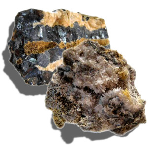
In a cycle of events called Cyclotherms, the distinctive series of beds of limestone, shale and sandstone that characterise Lunedale and other northern Pennine dales, were built up. Evidence of the marine origin of the Lunedale limestone can be seen within it as fossilised shells, corals and fragments of extinct creatures related to modern sea urchins and star fish.
Enormous forces in the earth's crust towards the end of the Carboniferous Period which bent, stretched, tilted and fractured the rocks and also enabled molten rock from deep within the earth to rise up and spread like jam between the existing rocks resulted in the distinctive geology of the dale today.
About 2 million years ago a period of global cooling caused the polar ice caps to extend southwards and cover much of Great Britain and northern Europe. The ice-sheets scoured the valleys and left glacial debris in their wake, mainly in the form of boulder clay. The last major ice-sheets covering our area melted away as recently as 11,500 years ago.
Read more about the geology of Lunedale in THE MAKING OF LUNEDALE - A brief journey through half a billion years of earth history by Brian Young, Retired British Geological Survey District Geologist for Northern England.
See images of geological samples and local mining and quarrying features
